City-usa.net
  • EUA
  • Estado
  • Bandeira
  • Mapa

Montgomery County

USA / Maryland / Montgomery County
Aspen Hill
Bethesda
Brookmont
Burtonsville
Cabin John
Chevy Chase
Chevy Chase Section Five
Chevy Chase Section Three
Chevy Chase View
Chevy Chase Village
Clarksburg
Cloverly
Colesville
Damascus
Darnestown
Fairland
Forest Glen
Friendship Village
Gaithersburg
Garrett Park
Germantown
Glen Echo
Hillandale
Kemp Mill
Kensington
Laytonsville
Montgomery Village
North Bethesda
North Chevy Chase
North Kensington
North Potomac
Olney
Poolesville
Potomac
Redland
Rockville
Rossmoor
Silver Spring
Somerset
South Kensington
Takoma Park
Travilah
Washington Grove
White Oak
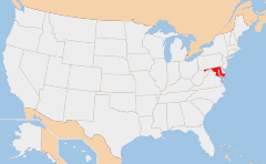
maryland map

Map of Maryland

DB-City :Montgomery County
HASC code :US-MD-MO
FIPS 6-4 code :24031
Capital :Rockville
Largest city :Silver Spring
Elevation :High : Damascus 828 ft
Low : Germantown 0 ft
Population :873,341
Land Area :495 sq mi
(1,282 km²)
Density :1,764.33/sq mi
(681.21/km²)
Time zone :UTC -5
Website :http://www.montgomerycountymd.gov
United States City
en - Condado de Maryland fr - Condado de Maryland de - Condado de Maryland es - Condado de Maryland it - Condado de Maryland pt - Condado de Maryland
nl - Condado de Maryland el - Condado de Maryland ru - Condado de Maryland ja - Condado de Maryland ko - Condado de Maryland zh - Condado de Maryland
City-USA.net O mais visitado Cidades no estado
ESTADOS UNIDOS indicam
Contato

Mapa
Sitemap
Forks, WA
Los Angeles, CA
New York, NY
Kearney, NE
Alabaster, AL
North Platte, NE
St. Charles
Waldorf
Baltimore
Elkridge
Potomac
Hagerstown
Adel, IA
Seiling, OK
Finley, WA
Grandview, WI
Kingston Springs, TN
Cockrell Hill, TX
© 2023 -